Forests face increasing threats from climate change and land use changes like deforestation. Effective forest management and conservation are vital for climate adaptation and mitigation, aligning with the UN’s Sustainable Development Goals (SDGs), the Bonn Challenge on forests, and the Glasgow Declaration on halting forest loss. Forest conservation efforts, including regeneration, afforestation, and reforestation, are essential for climate mitigation under the Paris Agreement. Precise and up-to-date high-resolution information about the structure, health, and carbon stocks of forests in the world is critical for promoting appropriate measures to tackle forest loss and to effectively combat climate change. However, traditional methods of assessing forest carbon stocks through field inventories are labor-intensive and lack the granularity needed for regional and local monitoring, failing to capture sudden losses from events like fires or insect attacks. Further, many countries also lack comprehensive inventories and use basic methods for estimating forest carbon changes.
To address this gap, the AI4Forest project, a collaboration between ZIB, LSCE Paris, University of Münster, ENS Paris, and TUM, aims to enhance the accuracy of forest monitoring through deep learning techniques by leveraging publicly available satellite data from optical, radar, and GEDI spaceborne sensors. One important application is the estimation of one of the Essential Climate Variables, namely the above-ground biomass (AGB), us-ing tree canopy height as a proxy. While GEDI provides only point measurements of canopy height, a comprehensive global height map is currently lacking.
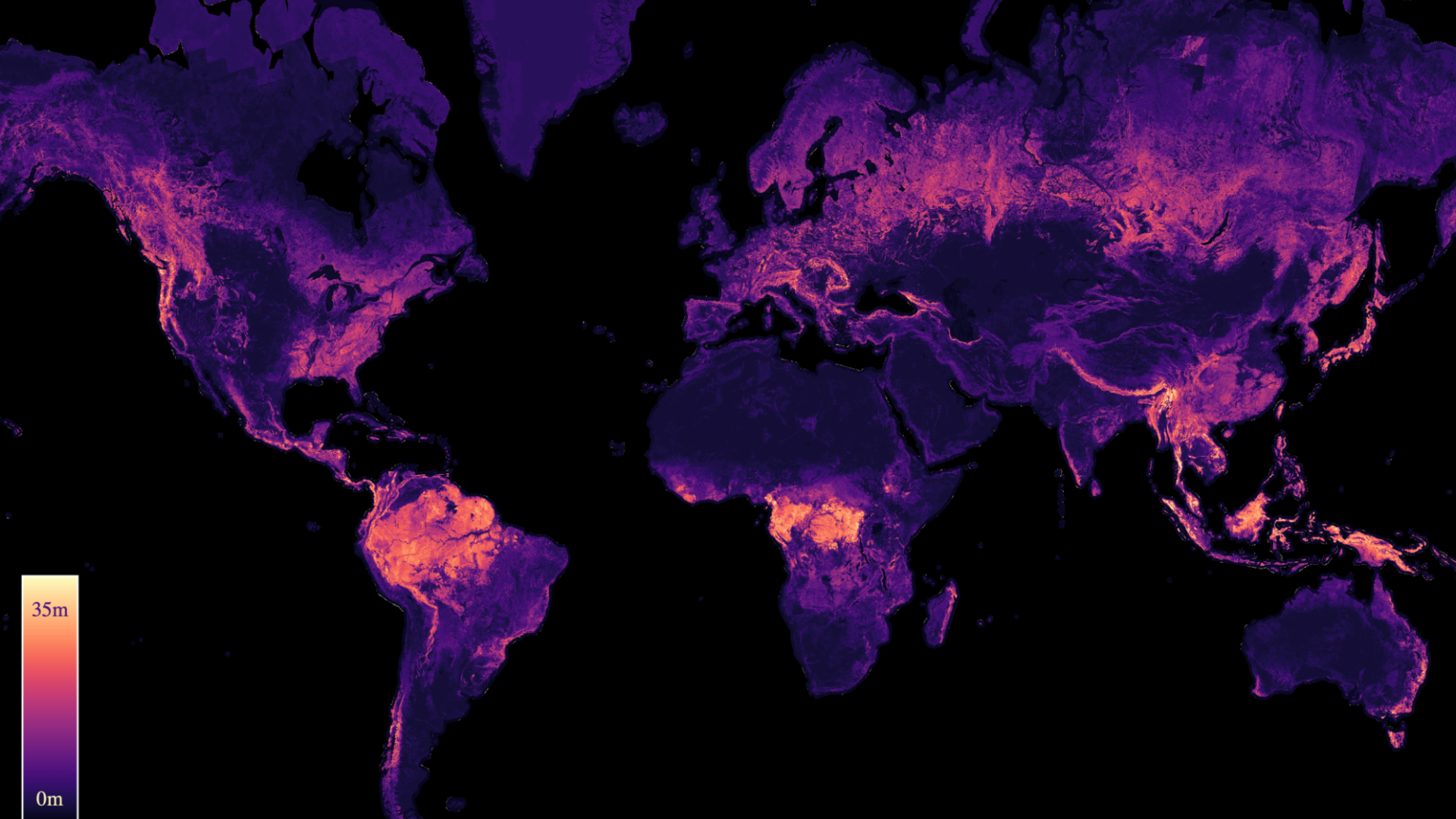
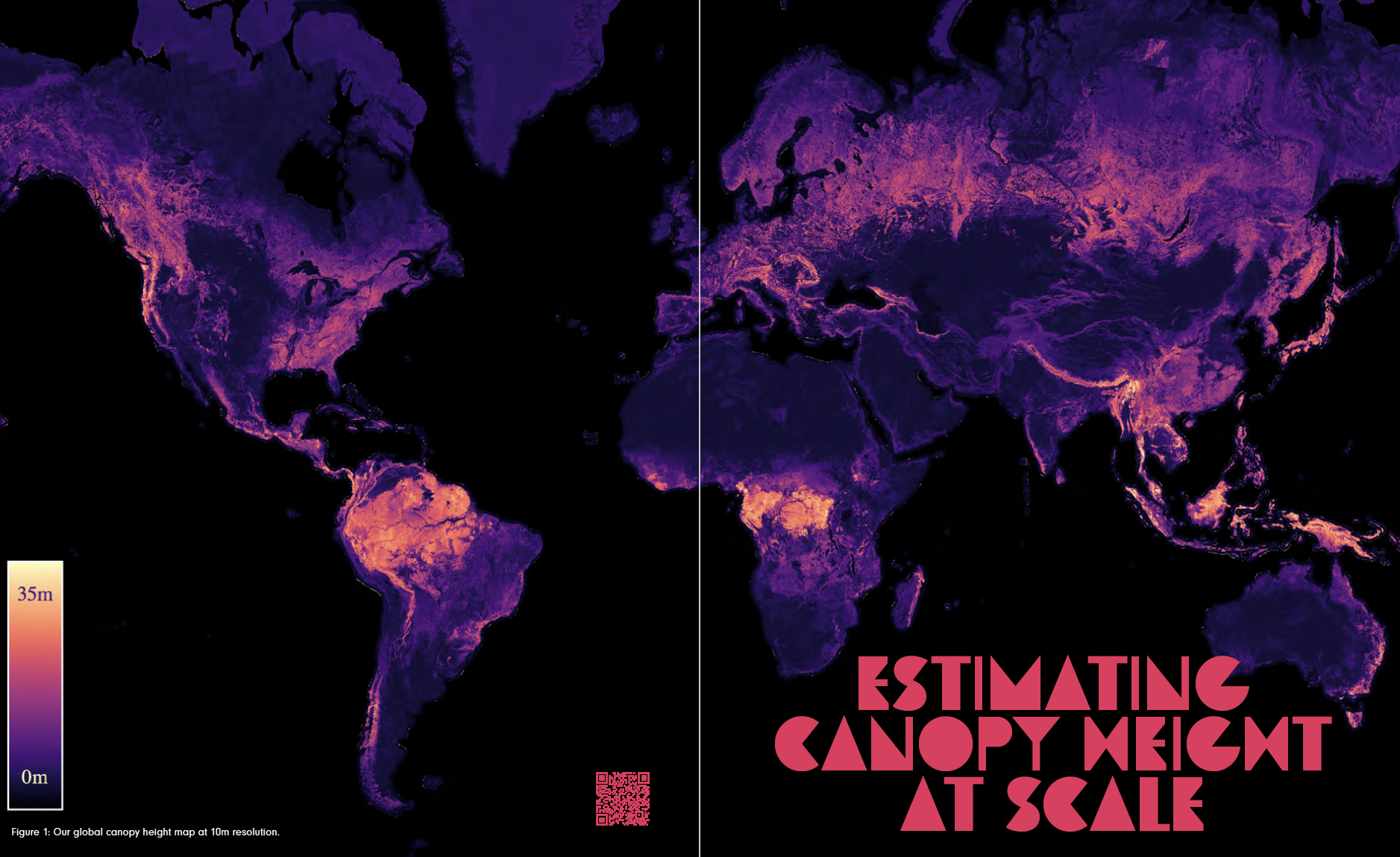
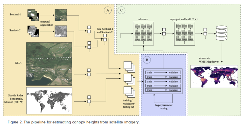
We were able to provide such a global canopy height map at 10m resolution by training a neural net-work that accurately predicts canopy heights from satellite imagery across large areas. Using four channels from Sentinel-1 and ten channels from Sentinel-2, we achieved a mean absolute error of 2.43m in canopy height predictions. Sparse GEDI point measurements served as the ground-truth for our model. Figure 2 gives a schematic over-view of our workflow. Our map significantly improves upon existing global-scale maps and can be used as a reference to derive more accurate biomass carbon stocks, helping policymakers to make more accurately informed decisions to guide forest management efforts.
We identified both the potential to further improve the resolution and accuracy of our canopy height map, as well as the limitation of our map in only showing estimates for the year 2020, without capturing temporal dynamics, which would allow for a better monitoring of forest health and disturbances. We have addressed both issues.
Our novel approach, which lever-ages a full 12-month time series of Sentinel-2 imagery rather than using a single aggregated composite, yields substantial performance gains by allowing the model to capture seasonal patterns and exploit geolocation shifts in satellite measurements. We present the first 10m resolution temporal canopy height map of the European continent for the period 2019–2022. This new map is significantly better than our previous one for 2020 and now also captures temporal dynamics, providing more precise estimates than previous studies.

A huge challenge we faced was the substantial amount of training data required. To cover monthly imagery from 2017 to 2023 for approximately 20,000 landmass tiles, we needed around 1200 TB of Sentinel-2 data. Despite these challenges, our pipeline and the resulting temporal height map are publicly available, enabling comprehensive large-scale monitoring of forests and facilitating future research and ecological analyses. A further direction of our work is to extend our map to the entire world. The current temporal map can be explored at https://europetreemap. projects.earthengine.app/view/temporalcanopyheight.
Jan Pauls, Max Zimmer, Berkant Turan, Sebastian Pokutta et al.